I never would have guessed I’d be in the internet rabbit hole triggered by an article in my ASU Alumni magazine. But in there I found “ASU releases photos of early Phoenix taken by McCulloch Brothers” describing a collection of 4500 photographs from 1884-1947 by two brothers who emigrated here from Scotland and ran a commercial photo studio in Phoenix.
The entire collection is found at https://repository.asu.edu/collections/244:
This collection houses commercial photographs showing city scenes, streets, architectural views and building construction, commercial activities, water development projects (including dams and canals), landscapes, and agriculture in and around Phoenix, Arizona. Of particular note are the images showing the construction of Frog Tanks Diversion Dam and Lake Pleasant (A101-A353, A357), Arizona guest ranches and resorts (A754-A803), and Roosevelt Dam and the Apache Trail (A357-A372 A378, A381-A392, A404, A409-A411, A413, A418, A472, A946B).
These photo capture Phoenix at its time just before emerging as a major metropolitan area in the 1950s. Kudos to Arizona State University for making the collection available AND for releasing them all under a Creative Commons Attribution-Non Commercial license.
I poked around and looked at images of Camelback Mountain with nothing but desert around it. Then I spent some time studying a 1946 photo of downtown Phoenix, looking east down Van Buren Avenue at Central Avenue:

Cityscape of Downtown Phoenix (1946) Creative Commons licensed image from ASU’s McCulloch Brothers collection
There’s a lot of auto businesses there, and just beyond Ray Busey Parts in the middle, you can spot St. Mary’s Basilica, built in 1914. For fun, I tried to get a Google Street View image as close to the view as I could manage:

Google Streetview image looking east on Van Buren Avenue
You have to peek around the Chase building to spot St Mary’s.
Then on a whim, I took a chance and put the name of my little town, Strawberry, into the search, and was pleased to find a local photo! This photo identified as Strawberry Hill, was taken May 16, 1926 in Pine, AZ.
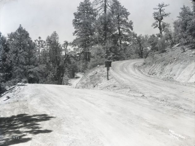
Creative Commons licensed image from ASU’s McCulloch Brothers collection
Its definitely the terrain around here, though I am hard pressed to identify the location. On downloading the original image, I was able to get a detailed view of the sign:

Detail of Strawberry Hill image
My guess is this is somewhere along the route of highway AZ87 leaving the town of Pine, it climbs the hill to Strawberry, and continues on to Long Valley, Winslow, Flagstaff.
Again, thanks to ASU for making these collection available, it might be a whole new pile of curiosity holes to explore.
Top / Featured Image: After looking at some of the Phoenix photos in ASU’s McCulloch Brothers photo collection, for fun, I tried searching for photos taken near where I lived. On trying “Payson” as a search term, I saw a photo of the East Verde River between Payson and Pine. Just for grins, I put in the search box the name for my town “Strawberry”, and after a few photos of fields of Strawberries, found this one identified as Strawberry Hill, taken May 16, 1926.
“Strawberry Hill,” McCulloch Brothers Inc. Photographs, CP MCLMB A696. Arizona State University Libraries: Arizona Collection. Photo is licensed Creative Commons Attribution-NonCommercial 4.0
