In my ongoing stream of “how can twitter be that awful when this happens daily”, I present the case of a geological cross section that yanked me far down the web rabbit hole.
My primary view into “bird space” (frankly that masto-term has as much goofiness as “toots”) is a Tweetdeck list, old school chronological organized of the main people I am most interested in (avert your eyes from the public stream and the algorithm-itized web side).
A few clicks back, an image jumped out from a @Brainpicker tweet:
I clicked not to read about Eisley’s cherishing (sorry Maria Popova, I treasure your posts) but to find out where did that old style Geologic diagram come from? That’s my academic background clicking into gear. Remember I have zero credentials in my ed ech field, instead a checkered past of Education = 1*B.S. + 1*M.S. + 0.5*PhD.
Well the post actually fits the image well as Popova frames Eisley’s writing with the metaphor of a slice through rock and time:
Descending into an enormous slit in Earth’s crust — “a perfect cross section through perhaps ten million years of time” — in search of fossils, Eiseley describes the skull he discovers entombed in stone several million years down this chute of time
https://www.themarginalian.org/2022/10/18/loren-eiseley-the-slit/
But that image, where is it from? The caption offers he entrance to the web rabbit hole, another kind of slit– “Geological strata from Geographical Portfolio by Levi Walter Yaggy, 1887. (Available as a print, benefitting The Nature Conservancy.)” That is what a hyperlink does, it is so simple, it opens a door for the curious. I still have tremors from seeing some of my organization’s work published on the web with nary a link.
Where does it go? Yikes, is this a dead end? It’s an online store from society6 where one guesses Maria Popova sells printed art work, as she says, where proceeds go to a good cause. But who the heck is Levi Walter Yaggy? That name is not one I recall from my studies.
The next step is doing a search on the print’s title “‘Geographical Portfolio’ by Levi Walter Yaggy, 1887” First link result (who the bleep had a viral tweet about Google search being a dead mall of no results?) takes me to:
Now I have some insight into this Yaggy guy- he was creating educational materials, and doing cutting edge interactive elements in 1887– and too, sadly, racist language on some maps.
In 1887 Levi Walter Yaggy published the Geographical Portfolio – Comprising Physical, Political, Geological, and Astronomical Geography with his publishing company, Western Publishing House of Chicago. The popular set of maps and charts (an expanded second edition was released six years later) was intended for teachers to use in classroom settings. The two by three-foot sheets used clever composite images to convey the range of topography and animals around the world, resulting in dense caves and steep mountain peaks that could be straight out of a fantasy novel.
In addition to their imaginative designs and eye-catching color palettes, Yaggy made strides in the teaching aid field by incorporating interactive elements. Each set included a 3-dimensional relief map of the United States and latches revealed hidden diagrams on individual charts. Unfortunately, despite his forward-thinking designs, Yaggy did include the era’s all-too-common racist depictions of non-white populations on some of his cultural maps.
But look at those retro looking richly detailed maps, not just the cross section but the Cosmos and landforms! They are rather eye catching.
As usual, I am wondering about the use / publishing of the images. Are they likely just old enough to be public domain? Most probable as that would enable Maria Popova to sell the cross section as a framed print.
There (again) is no specific attribution statement but the next link in this associative trail takes me to Yaggy’s maps in the David Rumsey archive. Now it has been quite a few web years since I visited but I remember Rumsey’s maps being on the web for a long time.
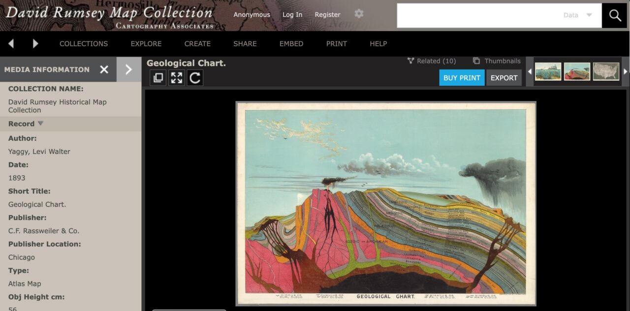
And thus we get to the Geologic Cross Section in the Rumsey Collection.
I cannot find any right’s statement, and it does take some digging down at the very bottom of the Rumsey Collection home page:
Copyright ©2022 Cartography Associates. All Rights Reserved. Learn more
Hmmm. Can this be the usual copyright dead end? No wait, below the text is an old school Creative Commons image. I go one more click deep to learn more as he URL suggests info on copyright and permissions.
This is downright refreshing!
Images from this web site and database may be reproduced or transmitted and used without charge for personal use or in any publication, either in print or digital media, by any for profit or non profit publisher.
https://www.davidrumsey.com/about/copyright-and-permissions
It does suggest contacting the copyright holders even for stuff like Yaggy’s maps that are older than 1924, but there explicitly is a Creative Commons BY-NC license. Go Yaggy! Go Rumsey!
I am still curious as to the person Levi Walter Yaggy and yikes! He does not exist in Wikipedia. Levi Walter Yaggy is a red link. Because I am currently taking the WikiEdu Wikidata Institute, I did find an item there for Mr Yaggy with a few biographical property items.
Way down at the bottom I spotted a link labeled COMMONs suggested Yaggy had a category in Wikimedia Commons. Bingo, he does. Here I found the same Geologic Chart as an image in Wikimedia Commons. The licensing info asserts a public domain status since it was published before 1927.
However, the image source link looks fishy, it goes to an entry for it from Barry Lawrence Ruderman Antique Map sales, indicating the copy of the map was sold. Yes, as a public domain image, maybe i does not matter where it was found,but I think the David Rumsey link is more suitable. I left a message on the Talk page, maybe I should just edit it.
But back to that cross section image, it’s worth some study,especially given it’s vintage. It’s schematic to show the geological epochs and eras, the layers perhaps not quite proportional, and then in the lower/oldest strata (now referred to as Pre-Cambrian) Huronian is an ancient glacial event. I cannot find a modern use of time for “laurentian”. And way in the most recent, Psychozoic is new to me– defined in Wiktionary as a rare geological term “Pertaining to the period of geological time characterized by the presence of human intelligence, the Psychozoic.” The modern term might be Anthropocene.
The layers more to the right are a bit more confusing, the seem to be names of geological units from these time periods? And maybe too,i looks like Yaggy tried to toss in some paleontology with Mastodons (no not than one) and typical rock types for the time period (which would depend where you made this cross section).
It’s more idealized, and despite some odd choices, the attempt to show these relations on a diagram, plus landforms and even erupting volcanoes, just makes me happy to explore.
Now I need to go back, and maybe create that Wikipedia article for Levi Walter Yaggy.
And all of this, came from curiosity from one image in a tweet among tweets. Follow those curiosities and I will see you maybe down in the rabbit holes of wonder!
Featured Image: Geologic Chart by Levi Walter Yaggy found in the David Rumsey Map Collection, most likely public domain but also maybe licensed Creative Commons CC BY-NC.

