I can’t stop the curiosity impulse and sometimes feel obliged to chase down source-less photos. So it started with a Cory Doctorow tweet (just follow him, you will not be sorry)
Why this image? It’s just road side Americana. Was it the tweet saying “circa 1970s” which was my childhood? That guess might be based on the vintage of the photo. The models of cars might push it to late 1960s but not too far.
The tweet goes to Wil Wheaton’s Tumblr (which might be the source of the 1970s). Tumblr… yes it still exists. It was the platform that really enabled that “reblog” / repost thing. a one click way to just post to your site what someone else did. It leaves a trail of unsourced media.
Wil (can I call you by first name) reblogged this from a tumblr called Every Day Life in the Past. End of trail because no one in tumblr attributes photos. That’s so not cool there.
What do we have there? A cafe named “Magic Chef” offering “Home Style Cooking” or maybe it was the “Eat Shop Cafe”– that’s pretty damned unique. Not. Search results for Magic Chef Cafe land you mostly in appliance land.
I did find another image (via Google Lens reverse search) of the same restaurant from a vintage postcard seller (“MAGIC CHEF CAFÉ RESTAURANT PEPSI COLA SIGN OLD CARS ADVERTISING POSTCARD COPY“, this image is the same place, but the cars are older:
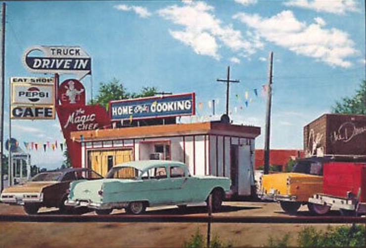
That could push it early 1960s? There seems to be a shop adjacent, some kind of Dance studio?
My trail ran cold. Most references to Magic Chef restaurant seemed to be ones that were later taken over and turned into other kinds of restaurants – Chinese, Filipino, one in Qatar, one in Abu Dhabi.
I thought maybe I would find a reference with an address and do the Google Street view visit, but alas, I went cold. Maybe someone else can go farther.
Not all the rabbit holing lands you some place, it just ends up some digging around. But always worth it. Well, to me.
UPDATE: March 1, 2022
See comments below as Eric Likeness has sleuthed this to the nth degree:
- See Getty image that matches the postcard one above, it’s stated as a 1976 photo?
- Also, same image from Worth Point that included an address- it was in Denver, 2459 South Santa Fe Drive.
- And finally, located in Google StreetView… not much to see now!
Eric wins the rabbit prized and also, for showing how the internet works- ask for help, offer help, it all makes for a nice circle.
Featured Image:

Wonder no longer brother, I went down the tubes and held my breath as long as possible and took a few Mike Caufield inspired steps to find this source: https://www.gettyimages.com/detail/news-photo/magic-chef-restaurant-every-restaurateur-worth-his-silver-news-photo/837010144
Check it out. The open web at work.
Doing some further sleuthing in Denver, looking for S. Santa Fe Dr. I found this unlikely neighborhood near route 85/CanAm Highway in Englewood, CO. https://goo.gl/maps/dn17xs9a6b8UvVKX6
There’s a little side street just off the highway called S. Santa Fe Dr. That would have been convenient to the highway (ergo Truck Stop in the sign). But you can tell by Google Maps, this plots been developed and redeveloped a few times. But who knows maybe this is the spot?
Plot thickens as I keep stepping laterally to find more info. This time I did a search: on the date of the photo and Denver post and turned up this link: https://www.worthpoint.com/worthopedia/1976-magic-chef-restaurant-cafe-press-410032751
And found EVEN more information. ” Photo Condition Magic Chef Restaurant – 2459 South Santa FE Drive “. So I looked that up and street view and found a more accurate “possible” location, where a street light now resides:
https://www.google.com/maps/place/2459+S+Santa+Fe+Dr,+Denver,+CO+80223/@39.6718789,-104.9951936,3a,75y,243.33h,96.32t/data=!3m7!1e1!3m5!1sGLK52ZrEyjuzrMdEjjiIjg!2e0!6shttps:%2F%2Fstreetviewpixels-pa.googleapis.com%2Fv1%2Fthumbnail%3Fpanoid%3DGLK52ZrEyjuzrMdEjjiIjg%26cb_client%3Dsearch.gws-prod.gps%26w%3D360%26h%3D120%26yaw%3D190.38097%26pitch%3D0%26thumbfov%3D100!7i16384!8i8192!4m5!3m4!1s0x876c7fc8cd68bc03:0xb5e17a9e9d50861f!8m2!3d39.6718456!4d-104.995318
Thanks again for finding it. I used to visit a cousin in Englewood, maybe I drove right past the spot.
Entirely possible. The location today looks a bit like it was a so-called “frontage” plot between the neighborhood houses and S. Sante Fe drive itself. But it seems like it’s just one plot separated from what is now Santa Fe Pottery, formerly Santa Fe Village (maybe a road-side motel, motor court at one time?). Definitely an interesting picture, interesting neighborhood and street location. Definitely street address looks accurate when doing the Street View through that section of Google Maps: 2459 South Santa FE Drive Denver CO. You can see the mountains as you look south while pinned to that street address.